.jpg)
Across the Desert: Trip Overview
- shaneberry9
- May 5, 2021
- 6 min read
First off, I wanted to give a huge thanks to a few people. A huge thanks to Eric and Sonnie- there is a 0% chance that we could have done this route without their generosity in letting us use their house as a staging area for every phase of our hike; when starting out, recuperating from injury, and at the end when we got back to Phoenix at 4am in a snowstorm, their place was always open to us. A huge thanks to Blisterfree and Tree- they really invented the corridor for this route, and we followed their actual track for about 50% of our hike. Having absolutely no experience with desert backpacking before this trip, I would have been utterly incapable of the large-scale route planning required for such an undertaking. We couldn't have done it without their excellent resources online. Check out their site here: https://blisterfree.wordpress.com/ and their trip report form their version of the route here: https://www.trailjournals.com/journal/entry/625665
This hike ended up being so much more harrowing, stressful, and bizarre than I ever could have predicted. I thought I had learned a lot about backpacking after having done the Appalachian Trail, and it was so incredibly humbling to make mistake after mistake due lack of knowledge and lack of preparation. It was an adventure to the last. The Sonoran and Mojave deserts are such a cool patchwork of low-traffic wilderness areas, offering solitude and the potential for big trips during a season when not much else is hikable. I am very excited to plan more routes through the area in the future.
Background:
Last year over winter break, I decided that I really wanted to do another long hike. And soon. I had the CDT coming up in a year and a half, and my kit had thoroughly evolved since finishing the Appalachian Trail. I wanted to get out on a month-long trip and test out gear and food strategies. Winter break seemed like a natural time to do this. The only problem was that winter break is, well, winter. The Rockies are snowbound. The Cascades and Sierras are buried. The AZT gets dumped on, the GET would be tricky. That left me with very few choices for a long-distance winter hike. I could do... the Florida Trail? A yo-yo of the Pinhoti? And then I came across the blog post on Brett's site. The WTH. A hike to do in winter. Perfect! The only problem was that I had literally never been to that part of the US. I had never backpacked in any sort of desert, ever. But the idea was in my head, and I couldn't shake it.
The Route:
The route I had planned before the hike, and the one I actually ended up hiking, are completely different. My original route went from Tonopah, AZ, to Ubehebe Crater, Death Valley. It took a snaking journey through the wilderness areas south of the Mojave, and bounced up and down the East rim of Death Valley with brazen confidence. All told, this route was about 900 miles of idiocy, a foolish, impossibly difficult undertaking. Don't get me wrong, I want to go back and redesign that route and then actually go out and hike it one day, in a wetter year if one ever comes again. But my experience going into the hike was nonexistent. I ended up reverting to Blisterfree's route in many places once our plans got scrambled due to both covid and injuries. This led to the ~470-mile route that we ended up hiking.
Parker Dam, CA to Ubehebe Crater, Death Valley
470 miles
The Desert Hike route is a pretty even mix of dirt roads and cross-country travel. It's hard to distinguish between the two though, as the dirt roads used are a full spectrum from active, graded dirt roads all the way down to crumbly tire tracks that likely haven't seen use in over 50 years. Some dirt roads were harder than cross-country right next to the road due to heavily-eroded tread or deep sand. So all in all, the distinction between dirt road and cross country really doesn't mean much on this route. Some of it is absurdly hard, some of it is absurdly easy, with no real rhyme or reason. The route does have a pleasant blend of harder mountain hiking and easier basin crossings-- right when you're getting bored of the mind-numbing straight, flat terrain, you hit mountains that provide a mental break. Once the mountains become too draining, you hit the end and enter another basin. Maybe 5% of the hike is on trails, most notably the Mid Hills Trail in the Mojave (which is basically cross-country for most of it), China Ranch into Tecopa, and Zabriskie Point in Death Valley.
Resupply + Water:
Resupply on this route was actually surprisingly straightforward. The route passes by post offices every 70-110 miles which makes for easy pickup of resupply packages. The one obvious gap is from Parker Dam to Baker. The trail goes through Fenner, CA right in the middle of this stretch which has a gas station with surprisingly decent resupply, but it is expensive. (I should know, I took a zero and a half outside that gas station.) If you were really against a gas station resupply or desperately needed to get into town, Needles is 30 miles east on the interstate. It's a busy exit, you'll get someone eventually. Also, if you're ever in Shoshone I highly recommend the local chips and salsa sold by the Charlie Brown General Store. I went through two bags of chips and a jar of salsa in Shoshone. I tried to see if I could order the chips and salsa online, but I haven't had any luck so far.

The resupply sheet starts at the planned start- I hiked from Tonopah to Wenden, then Parker Dam to the end. Don't trust my mileage- it's been through a lot of revisions and things have likely been lost in translation.
The water situation on this route is a completely different story. I meticulously went over the route in the planning phase: I looked at historic google earth imagery for cow ponds, I read USGS surveys for seasonal springs, I used what scant trip reports I could find and tried to extrapolate spring reliability from visitors who hadn't been relying on the water or incredibly interested in water flow. I made a huge spreadsheet with water sources, descriptions, reliability, and mileages. And then I ended up scrapping everything. Apparently the monsoon rains hadn't arrived in Arizona that summer, and it had overall been a dry year in the middle of an already historic drought across the West. After springs, cow ponds, wildlife guzzlers, even a large-scale agricultural diversion all turned up dry, Jet Fighter and I realized that we had to scrap my previous water plans and only rely on the surest of springs based on long-term groundwater recharge. Even then we barely scraped by through the start of the Mojave, having to settle for absolutely disgusting water sources, and Death Valley's Marble Canyon was a big scare. Water carries in the 20-30 mile range ended up being the norm for the entirety of the hike, and we had 4 carries of 40+ miles.
It is honestly going to be quite a while before I'll be willing to try something with such a tenuous, unknown water situation again. Just writing this trip report about the first few days of hiking made me stressed out again, and the fear that accompanied each water source on this hike went beyond challenging type-2 fun; it just isn't worth repeating. That being said, the entire region got swamped by an enormous rain/snowstorm the day after we ended our hike. This likely filled up all the wildlife guzzlers, ephemeral springs, and other pockets of water for a good bit of time. If you're willing to wait and time your hike with some winter rains you will probably have a completely different experience than mine.
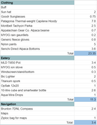
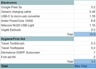
The Gear:

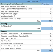


I don't have that much to say about the gear I used; it performed flawlessly for the most part. I was extremely pleased with my DCF pack, which did an outstanding job with the rugged off-trail travel. It withstood vicious acacia, unceremonious tumbles down dryfalls, and stubborn rodents and ended up with just one 1-cm scratch through the top. My sleeping bag and outer layers were perfect as well; I never needed more but rarely had a day where I didn't need one of them ever. I do wish I had caved and bought a legitimate desert long-sleeve and pants. The tight-fitting polyester running shirt that I wore conducted heat from the sun right onto my skin and was generallly too warm on the hotter days. I had planned on wearing running shorts mostly, but the strong low-angle sun baked my legs on the first day and I pretty much wore pants for the rest of the hike. These cheapo nylon pants got absolutely shredded by thorns and rocks, while also being quite toasty because of their color. They will not be accompanying me on any hikes in the future.


Comments